Mmdb-server - An open source fast API server to lookup IP addresses for their geographic location

Overview

mmdb-server

mmdb-server is an open source fast API server to lookup IP addresses for their geographic location. The server can be used with any MaxMind DB File Format or file in the same format.

mmdb-server includes a free and open GeoOpen-Country database for IPv4 and IPv6 addresses. The file GeoOpen-Country is generated on a regular basis from AS announces and their respective whois records.

Installation

Python 3.8+ is required to run the mmdb-server with some additional requirements.

  • pip3 install -r REQUIREMENTS
  • cp ./etc/server.conf.sample ./etc/server.conf
  • cd bin; python3 server.py

Usage

Lookup of an IP address

curl -s http://127.0.0.1:8000/geolookup/188.65.220.25 | jq .

[
  {
    "country": {
      "iso_code": "BE"
    },
    "meta": {
      "description": {
        "en": "Geo Open MMDB database - https://github.com/adulau/mmdb-server"
      },
      "build_db": "2022-01-23 16:13:05",
      "db_source": "GeoOpen-Country",
      "nb_nodes": 1156125
    }
  }
]

$ curl -s http://127.0.0.1:8000/geolookup/2a02:21d0::68:69:25 | jq .

[
  {
    "country": {
      "iso_code": "BE"
    },
    "meta": {
      "description": {
        "en": "Geo Open MMDB database - https://github.com/adulau/mmdb-server"
      },
      "build_db": "2022-01-23 16:13:05",
      "db_source": "GeoOpen-Country",
      "nb_nodes": 1156125
    }
  }
]

Output format

The output format is an array of JSON object (to support the ability to serve multiple geo location database). Each JSON object of the JSON array includes a meta and a country fields. The country give the geographic location of the IP address queried. The meta field includes the origin of the MMDB database which the the metadata.

License

    Copyright (C) 2022 Alexandre Dulaunoy 

    This program is free software: you can redistribute it and/or modify
    it under the terms of the GNU Affero General Public License as published by
    the Free Software Foundation, either version 3 of the License, or
    (at your option) any later version.

    This program is distributed in the hope that it will be useful,
    but WITHOUT ANY WARRANTY; without even the implied warranty of
    MERCHANTABILITY or FITNESS FOR A PARTICULAR PURPOSE.  See the
    GNU Affero General Public License for more details.

    You should have received a copy of the GNU Affero General Public License
    along with this program.  If not, see 
   .
You might also like...
LicenseLocation - License Location With Python

LicenseLocation Hi,everyone! ❤ 🧡 💛 💚 💙 💜 This is my first project! ✔ Actual

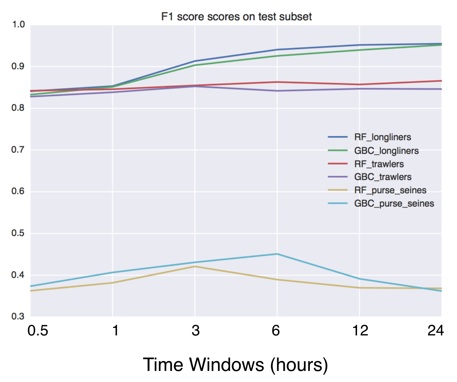
Using Global fishing watch's data to build a machine learning model that can identify illegal fishing and poaching activities through satellite and geo-location data.

Using Global fishing watch's data to build a machine learning model that can identify illegal fishing and poaching activities through satellite and geo-location data.

Script that allows to download data with satellite's orbit height and create CSV with their change in time.

Satellite orbit height ◾ Requirements Python = 3.8 Packages listen in reuirements.txt (run pip install -r requirements.txt) Account on Space Track ◾

Helping data scientists better understand their datasets and models in text classification. With love from ServiceNow.

Azimuth, an open-source dataset and error analysis tool for text classification, with love from ServiceNow. Overview Azimuth is an open source applica

A package built to support working with spatial data using open source python

EarthPy EarthPy makes it easier to plot and manipulate spatial data in Python. Why EarthPy? Python is a generic programming language designed to suppo

GeoNode is an open source platform that facilitates the creation, sharing, and collaborative use of geospatial data.

Table of Contents What is GeoNode? Try out GeoNode Install Learn GeoNode Development Contributing Roadmap Showcase Most useful links Licensing What is

GebPy is a Python-based, open source tool for the generation of geological data of minerals, rocks and complete lithological sequences.

GebPy is a Python-based, open source tool for the generation of geological data of minerals, rocks and complete lithological sequences. The data can be generated randomly or with respect to user-defined constraints, for example a specific element concentration within minerals and rocks or the order of units within a complete lithological profile.

Tile Map Service and OGC Tiles API for QGIS Server

Tiles API Add tiles API to QGIS Server Tiles Map Service API OGC Tiles API Tile Map Service API - TMS The TMS API provides these URLs: /tms/? to get i

Zora is a python program that searches for GeoLocation info for given CIDR networks , with options to search with API or without API

Zora Zora is a python program that searches for GeoLocation info for given CIDR networks , with options to search with API or without API Installing a

Releases(v1.1)
  • v1.1(Oct 15, 2022)

  • v1.0(Jul 9, 2022)

    mmdb-server v1.0 released - an open source fast API server to lookup IP addresses for their geographic location. The server reached version 1.0 as many production servers are running flawlessly with this code. mmdb-server includes the geo-open database from CIRCL.

    Source code(tar.gz)
    Source code(zip)
  • v0.5(Feb 6, 2022)

    mmdb-server (the open and free geo IP server) version 0.5 released (2022-02-06) 🗺️

    mmdb-server (the open and free geo IP server) version 0.5 released which includes the support for to load multiple MMDB files.

    A new GeoOpen database included to support AS number and AS description lookup.

    New

    • [multiple MMDB file support] MMDB server can now load a list of MMDB files + new GeoOpen file including ASN details added as example. [Alexandre Dulaunoy]

      GeoOpen files for country only -> https://cra.circl.lu/opendata/geo-open/mmdb-country/ GeoOpen files with country and ASN/ASN description -> https://cra.circl.lu/opendata/geo-open/mmdb-country-asn/

    • [db] Country-ASN db added. [Alexandre Dulaunoy]

    • [db] GeoOpen database updated. [Alexandre Dulaunoy]

    Changes

    • [doc] update the documentation and examples with the multiple sources. [Alexandre Dulaunoy]

    • [log] remove old debug. [Alexandre Dulaunoy]

    • [db] renamed. [Alexandre Dulaunoy]

    • [GeoOpen-country] updated. [Alexandre Dulaunoy]

    Other

    • Update README.md. [Alexandre Dulaunoy]
    Source code(tar.gz)
    Source code(zip)
  • v0.2(Jan 24, 2022)

    What's new in v0.2 (2022-01-24)

    New

    • [server] Add additional information about the country including average location, complete name and numeric code. [Alexandre Dulaunoy]

    • [mygeolookup] Query on root of the server will give the geo location of the remote IP address doing the query. [Alexandre Dulaunoy]

    Changes

    • [doc] update JSON output and CIRCL public service. [Alexandre Dulaunoy]

    • [server] display port. [Alexandre Dulaunoy]

    • [server] make port configurable. [Alexandre Dulaunoy]

    Source code(tar.gz)
    Source code(zip)
  • v0.1(Jan 23, 2022)

    mmdb-server is an open source fast API server to lookup IP addresses for their geographic location. The server can be used with any MaxMind DB File Format or file in the same format.

    mmdb-server includes a free and open GeoOpen-Country database for IPv4 and IPv6 addresses. The file GeoOpen-Country is generated on a regular basis from AS announces and their respective whois records.

    Installation

    Python 3.8+ is required to run the mmdb-server with some additional requirements.

    • pip3 install -r REQUIREMENTS
    • cp ./etc/server.conf.sample ./etc/server.conf
    • cd bin; python3 server.py

    Usage

    Lookup of an IP address

    curl -s http://127.0.0.1:8000/geolookup/188.65.220.25 | jq .

    [
      {
        "country": {
          "iso_code": "BE"
        },
        "meta": {
          "description": {
            "en": "Geo Open MMDB database - https://github.com/adulau/mmdb-server"
          },
          "build_db": "2022-01-23 16:13:05",
          "db_source": "GeoOpen-Country",
          "nb_nodes": 1156125
        }
      }
    ]
    

    $ curl -s http://127.0.0.1:8000/geolookup/2a02:21d0::68:69:25 | jq .

    [
      {
        "country": {
          "iso_code": "BE"
        },
        "meta": {
          "description": {
            "en": "Geo Open MMDB database - https://github.com/adulau/mmdb-server"
          },
          "build_db": "2022-01-23 16:13:05",
          "db_source": "GeoOpen-Country",
          "nb_nodes": 1156125
        }
      }
    ]
    

    Output format

    The output format is an array of JSON object (to support the ability to serve multiple geo location database). Each JSON object of the JSON array includes a meta and a country fields. The country give the geo graphic location of the IP address queried. The meta field includes the origin of the MMDB database which the the metadata.

    Source code(tar.gz)
    Source code(zip)
Owner
Alexandre Dulaunoy
Enjoy when human are using machines in unexpected ways. I break stuff and I do stuff.
Alexandre Dulaunoy
ProjPicker (projection picker) is a Python module that allows the user to select all coordinate reference systems (CRSs)

ProjPicker ProjPicker (projection picker) is a Python module that allows the user to select all coordinate reference systems (CRSs) whose extent compl

Huidae Cho 4 Feb 06, 2022
r.cfdtools 7 Dec 28, 2022
Open Data Cube analyses continental scale Earth Observation data through time

Open Data Cube Core Overview The Open Data Cube Core provides an integrated gridded data analysis environment for decades of analysis ready earth obse

Open Data Cube 410 Dec 13, 2022
Starlite-tile38 - Showcase using Tile38 via pyle38 in a Starlite application

Starlite-Tile38 Showcase using Tile38 via pyle38 in a Starlite application. Repo

Ben 8 Aug 07, 2022
Python bindings to libpostal for fast international address parsing/normalization

pypostal These are the official Python bindings to https://github.com/openvenues/libpostal, a fast statistical parser/normalizer for street addresses

openvenues 651 Dec 16, 2022
3D extension built off of shapely to make working with geospatial/trajectory data easier in python.

PyGeoShape 3D extension to shapely and pyproj to make working with geospatial/trajectory data easier in python. Getting Started Installation pip The e

Marc Brittain 5 Dec 27, 2022
A compilation of several single-beam bathymetry surveys of the Caribbean

Caribbean - Single-beam bathymetry This dataset is a compilation of several single-beam bathymetry surveys of the Caribbean ocean displaying a wide ra

Fatiando a Terra Datasets 0 Jan 20, 2022
Fiona reads and writes geographic data files

Fiona Fiona reads and writes geographic data files and thereby helps Python programmers integrate geographic information systems with other computer s

987 Jan 04, 2023
Django model field that can hold a geoposition, and corresponding widget

django-geoposition A model field that can hold a geoposition (latitude/longitude), and corresponding admin/form widget. Prerequisites Starting with ve

Philipp Bosch 324 Oct 17, 2022
Open GeoJSON data on geojson.io

geojsonio.py Open GeoJSON data on geojson.io from Python. geojsonio.py also contains a command line utility that is a Python port of geojsonio-cli. Us

Jacob Wasserman 114 Dec 21, 2022
Extract GoPro highlights and GPMF data.

Python script that parses the gpmd stream for GOPRO moov track (MP4) and extract the GPS info into a GPX (and kml) file.

Chris Auron 2 May 13, 2022
iNaturalist observations along hiking trails

This tool reads the route of a hike and generates a table of iNaturalist observations along the trails. It also shows the observations and the route of the hike on a map. Moreover, it saves waypoints

7 Nov 11, 2022
A bot that tweets info and location map for new bicycle parking added to OpenStreetMap within a GeoJSON boundary.

Bike parking tweepy bot app A twitter bot app that searches for bicycle parking added to OpenStreetMap. Relies on AWS Lambda/S3, Python3, Tweepy, Flas

Angelo Trivisonno 1 Dec 19, 2021
Python project to generate Kerala's distrcit level panchayath map.

Kerala-Panchayath-Maps Python project to generate Kerala's distrcit level panchayath map. As of now, geojson files of Kollam and Kozhikode are added t

Athul R T 2 Jan 10, 2022
Download and process satellite imagery in Python using Sentinel Hub services.

Description The sentinelhub Python package allows users to make OGC (WMS and WCS) web requests to download and process satellite images within your Py

Sentinel Hub 659 Dec 23, 2022
GetOSM is an OpenStreetMap tile downloader written in Python that is agnostic of GUI frameworks.

GetOSM GetOSM is an OpenStreetMap tile downloader written in Python that is agnostic of GUI frameworks. It is used with tkinter by ProjPicker. Require

Huidae Cho 3 May 20, 2022
Color correction plugin for rasterio

rio-color A rasterio plugin for applying basic color-oriented image operations to geospatial rasters. Goals No heavy dependencies: rio-color is purpos

Mapbox 111 Nov 15, 2022
Bacon - Band-limited Coordinate Networks for Multiscale Scene Representation

BACON: Band-limited Coordinate Networks for Multiscale Scene Representation Project Page | Video | Paper Official PyTorch implementation of BACON. BAC

Stanford Computational Imaging Lab 144 Dec 29, 2022
A ninja python package that unifies the Google Earth Engine ecosystem.

A Python package that unifies the Google Earth Engine ecosystem. EarthEngine.jl | rgee | rgee+ | eemont GitHub: https://github.com/r-earthengine/ee_ex

47 Dec 27, 2022
pure-Python (Numpy optional) 3D coordinate conversions for geospace ecef enu eci

Python 3-D coordinate conversions Pure Python (no prerequistes beyond Python itself) 3-D geographic coordinate conversions and geodesy. API similar to

Geospace code 292 Dec 29, 2022