Using Global fishing watch's data to build a machine learning model that can identify illegal fishing and poaching activities through satellite and geo-location data.

Overview

Catching-Illegal-Fishing

Using Global fishing watch's data to build a machine learning model that can identify illegal fishing and poaching activities through satellite and geo-location data.

Global fishing watch is a partnership between Google and Oceana to map all trackable fishing activity in world, in almost real time. This is a personal project using the data provided by global fishing watch.

The data provided has vessel ids, types and coordinates of encountered vessels.

Given same vessel type and are, a fishing vessel has a different trajectory than a non fishing vessel. I used the data provided to train my model on predicting whether a vessel is fishing or not.

#Local Environment Setup Python 3.7++ Tensorflow version >1.14.0,<2.0 from (https://www.tensorflow.org/get_started/os_setup) pip install google-api-python-client pyyaml pytz newlinejson python-dateutil yattag

#Model Result image

image

image

image

image

image

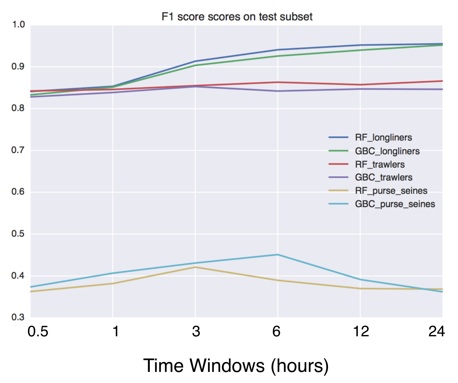
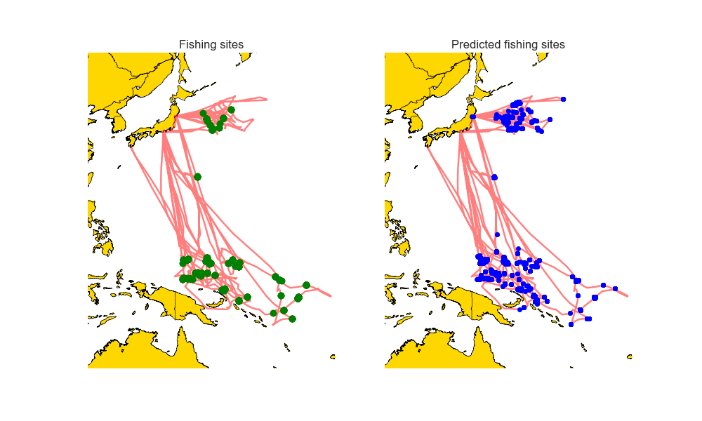
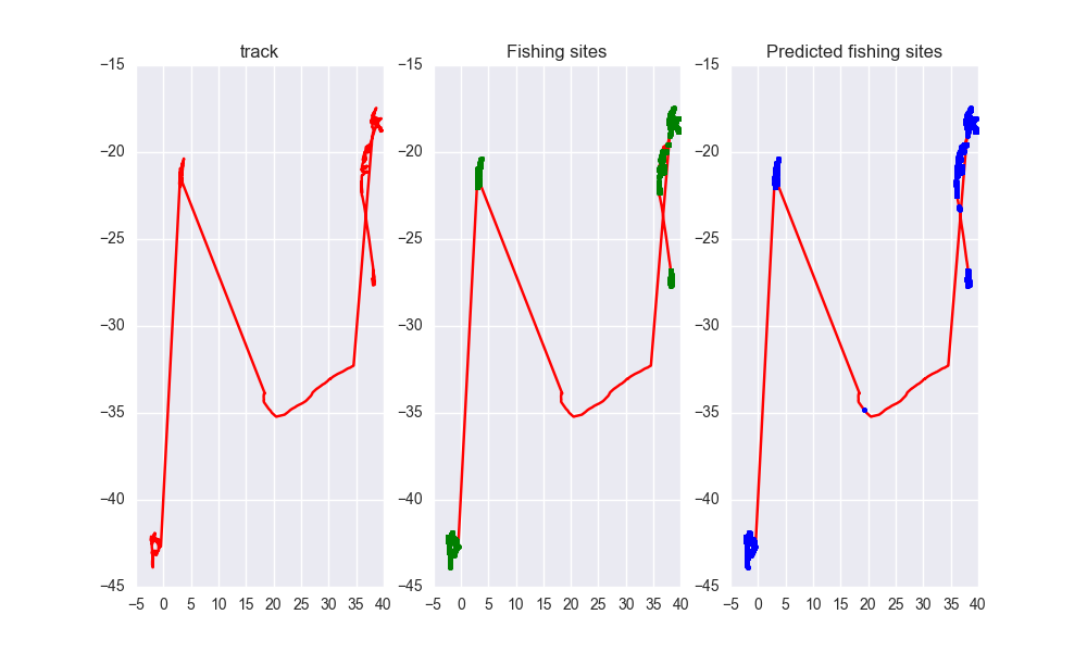
As you can see the predicted tracks are extremely close to the real paths.

Owner
Ayush Mishra
Machine Learning enthusiast.
Ayush Mishra
Search and download Copernicus Sentinel satellite images

sentinelsat Sentinelsat makes searching, downloading and retrieving the metadata of Sentinel satellite images from the Copernicus Open Access Hub easy

837 Dec 28, 2022
peartree: A library for converting transit data into a directed graph for sketch network analysis.

peartree 🍐 🌳 peartree is a library for converting GTFS feed schedules into a representative directed network graph. The tool uses Partridge to conve

Kuan Butts 183 Dec 29, 2022
Logging the position of the car on an sdcard

audi-mmi-3g-gps-logging Logging the position of the car on an sdcard, startup script origin not clear to me, logging setup and time change is what I d

2 May 31, 2022
Using Global fishing watch's data to build a machine learning model that can identify illegal fishing and poaching activities through satellite and geo-location data.

Using Global fishing watch's data to build a machine learning model that can identify illegal fishing and poaching activities through satellite and geo-location data.

Ayush Mishra 3 May 06, 2022
Automated download of LANDSAT data from USGS website

LANDSAT-Download It seems USGS has changed the structure of its data, and so far, I have not been able to find the direct links to the products? Help

Olivier Hagolle 197 Dec 30, 2022
Map Ookla server locations as a Kernel Density Estimation (KDE) geographic map plot.

Ookla Server KDE Plotting This notebook was created to map Ookla server locations as a Kernel Density Estimation (KDE) geographic map plot. Currently,

Jonathan Lo 1 Feb 12, 2022
Asynchronous Client for the worlds fastest in-memory geo-database Tile38

This is an asynchonous Python client for Tile38 that allows for fast and easy interaction with the worlds fastest in-memory geodatabase Tile38.

Ben 53 Dec 29, 2022
This is the antenna performance plotted from tinyGS reception data.

tinyGS-antenna-map This is the antenna performance plotted from tinyGS reception data. See their repository. The code produces a plot that provides Az

Martin J. Levy 14 Aug 21, 2022
Script that allows to download data with satellite's orbit height and create CSV with their change in time.

Satellite orbit height ◾ Requirements Python = 3.8 Packages listen in reuirements.txt (run pip install -r requirements.txt) Account on Space Track ◾

Alicja Musiał 2 Jan 17, 2022
Python tools for geographic data

GeoPandas Python tools for geographic data Introduction GeoPandas is a project to add support for geographic data to pandas objects. It currently impl

GeoPandas 3.5k Jan 03, 2023
Build, deploy and extract satellite public constellations with one command line.

SatExtractor Build, deploy and extract satellite public constellations with one command line. Table of Contents About The Project Getting Started Stru

Frontier Development Lab 70 Nov 18, 2022
Spatial Interpolation Toolbox is a Python-based GUI that is able to interpolate spatial data in vector format.

Spatial Interpolation Toolbox This is the home to Spatial Interpolation Toolbox, a graphical user interface (GUI) for interpolating geographic vector

Michael Ward 2 Nov 01, 2021
GeoIP Legacy Python API

MaxMind GeoIP Legacy Python Extension API Requirements Python 2.5+ or 3.3+ GeoIP Legacy C Library 1.4.7 or greater Installation With pip: $ pip instal

MaxMind 230 Nov 10, 2022
Track International space station with python

NASA-ISS-tracker Track International space station with python Modules import json import turtle import urllib.request import time import webbrowser i

Nikhil Yadav 8 Aug 12, 2021
Python module to access the OpenCage geocoding API

OpenCage Geocoding Module for Python A Python module to access the OpenCage Geocoder. Build Status / Code Quality / etc Usage Supports Python 3.6 or n

OpenCage GmbH 57 Nov 01, 2022
This repository contains the scripts to derivate the ENU and ECEF coordinates from the longitude, latitude, and altitude values encoded in the NAD83 coordinates.

This repository contains the scripts to derivate the ENU and ECEF coordinates from the longitude, latitude, and altitude values encoded in the NAD83 coordinates.

Luigi Cruz 1 Feb 07, 2022
Platform for building statistical models of cities and regions

UrbanSim UrbanSim is a platform for building statistical models of cities and regions. These models help forecast long-range patterns in real estate d

Urban Data Science Toolkit 419 Dec 30, 2022
Python bindings and utilities for GeoJSON

geojson This Python library contains: Functions for encoding and decoding GeoJSON formatted data Classes for all GeoJSON Objects An implementation of

Jazzband 765 Jan 06, 2023
A part of HyRiver software stack for handling geospatial data manipulations

Package Description Status PyNHD Navigate and subset NHDPlus (MR and HR) using web services Py3DEP Access topographic data through National Map's 3DEP

Taher Chegini 5 Dec 14, 2022
Pure Python NetCDF file reader and writer

Pyncf Pure Python NetCDF file reading and writing. Introduction Inspired by the pyshp library, which provides simple pythonic and dependency free data

Karim Bahgat 14 Sep 30, 2022