Program that shows all the details of the given IP address. Build with Python and ipinfo.io API

Overview

ip-details

This is a program that shows all the details of the given IP address. Build with Python and ipinfo.io API

Usage

To use this program, run the main Batch or Shell file, entering an IPv4 address as argument.

$ ip 1.1.1.1

You can also add the --save or -s flag, to save the output to a file. The file will be named details.log, and will be stored inside the saves directory of the program (saves/details.log).

$ ip 1.1.1.1 --save

Or, if prefered:

$ ip 1.1.1.1 -s

Example

$ ip 1.1.1.1

IP : 1.1.1.1
CITY : Miami
REGION : Florida
COUNTRY : US
LOC : 25.7867,-80.1800
ORG : AS13335 Cloudflare, Inc.
POSTAL : 33132
TIMEZONE : America/New_York
MAP : https://maps.google.com/maps/search/25.7867,-80.1800

And with the save option:

$ ip 1.1.1.1 --save

IP : 1.1.1.1
CITY : Miami
REGION : Florida
COUNTRY : US
LOC : 25.7867,-80.1800
ORG : AS13335 Cloudflare, Inc.
POSTAL : 33132
TIMEZONE : America/New_York
MAP : https://maps.google.com/maps/search/25.7867,-80.1800

Data saved to saves/details.log

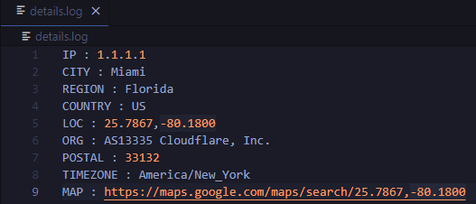
details.log file:

image

Requirements

Python programming language

Requests python library (pip install requests)
Python script that can be used to generate latitude/longitude coordinates for GOES-16 full-disk extent.

goes-latlon Python script that can be used to generate latitude/longitude coordinates for GOES-16 full-disk extent. 🌎 🛰️ The grid files can be acces

Douglas Uba 3 Apr 06, 2022
Python project to generate Kerala's distrcit level panchayath map.

Kerala-Panchayath-Maps Python project to generate Kerala's distrcit level panchayath map. As of now, geojson files of Kollam and Kozhikode are added t

Athul R T 2 Jan 10, 2022
Python module and script to interact with the Tractive GPS tracker.

pyTractive GPS Python module and script to interact with the Tractive GPS tracker. Requirements Python 3 geopy folium pandas pillow usage: main.py [-h

Dr. Usman Kayani 3 Nov 16, 2022
A Jupyter - Leaflet.js bridge

ipyleaflet A Jupyter / Leaflet bridge enabling interactive maps in the Jupyter notebook. Usage Selecting a basemap for a leaflet map: Loading a geojso

Jupyter Widgets 1.3k Dec 27, 2022
A multi-page streamlit app for the geospatial community.

A multi-page streamlit app for the geospatial community.

Qiusheng Wu 522 Dec 30, 2022
Geospatial web application developed uisng earthengine, geemap, and streamlit.

geospatial-streamlit Geospatial web applications developed uisng earthengine, geemap, and streamlit. App 1 - Land Surface Temperature A simple, code-f

13 Nov 27, 2022
Get Landsat surface reflectance time-series from google earth engine

geextract Google Earth Engine data extraction tool. Quickly obtain Landsat multispectral time-series for exploratory analysis and algorithm testing On

Loïc Dutrieux 50 Dec 15, 2022
Manage your XYZ Hub or HERE Data Hub spaces from Python.

XYZ Spaces for Python Manage your XYZ Hub or HERE Data Hub spaces and Interactive Map Layer from Python. FEATURED IN: Online Python Machine Learning C

HERE Technologies 30 Oct 18, 2022
Documentation and samples for ArcGIS API for Python

ArcGIS API for Python ArcGIS API for Python is a Python library for working with maps and geospatial data, powered by web GIS. It provides simple and

Esri 1.4k Dec 30, 2022
A package to fetch sentinel 2 Satellite data from Google.

Sentinel 2 Data Fetcher Installation Create a Virtual Environment and activate it. python3 -m venv venv . venv/bin/activate Install the Package via pi

1 Nov 18, 2021
Pure python WMS

Ogcserver Python WMS implementation using Mapnik. Depends Mapnik = 0.7.0 (and python bindings) Pillow PasteScript WebOb You will need to install Map

Mapnik 130 Dec 28, 2022
Geographic add-ons for Django REST Framework. Maintained by the OpenWISP Project.

django-rest-framework-gis Geographic add-ons for Django Rest Framework - Mailing List. Install last stable version from pypi pip install djangorestfra

OpenWISP 981 Jan 03, 2023
GeoNode is an open source platform that facilitates the creation, sharing, and collaborative use of geospatial data.

Table of Contents What is GeoNode? Try out GeoNode Install Learn GeoNode Development Contributing Roadmap Showcase Most useful links Licensing What is

GeoNode Development Team 1.2k Dec 26, 2022
FDTD simulator that generates s-parameters from OFF geometry files using a GPU

Emport Overview This repo provides a FDTD (Finite Differences Time Domain) simulator called emport for solving RF circuits. Emport outputs its simulat

4 Dec 15, 2022
Geodata extensions for Django REST Framework

Django-Spillway Django and Django REST Framework integration of raster and feature based geodata. Spillway builds on the immensely marvelous Django RE

Brian Galey 62 Jan 04, 2023
Get-countries-info - A python code that fetches data of any country

Country-info A python code getting countries information including country's map

CODE 2 Feb 21, 2022
Logging the position of the car on an sdcard

audi-mmi-3g-gps-logging Logging the position of the car on an sdcard, startup script origin not clear to me, logging setup and time change is what I d

2 May 31, 2022
Python bindings to libpostal for fast international address parsing/normalization

pypostal These are the official Python bindings to https://github.com/openvenues/libpostal, a fast statistical parser/normalizer for street addresses

openvenues 651 Dec 16, 2022
Minimum Bounding Box of Geospatial data

BBOX Problem definition: The spatial data users often are required to obtain the coordinates of the minimum bounding box of vector and raster data in

Ali Khosravi Kazazi 1 Sep 08, 2022
EOReader is a multi-satellite reader allowing you to open optical and SAR data.

Remote-sensing opensource python library reading optical and SAR sensors, loading and stacking bands, clouds, DEM and index.

ICube-SERTIT 152 Dec 30, 2022