gpdvega is a bridge between GeoPandas and Altair that allows to seamlessly chart geospatial data

Overview

gpdvega Coverage Status Build Status HitCount GitHub license GitHub issues

gpdvega is a bridge between GeoPandas a geospatial extension of Pandas and the declarative statistical visualization library Altair, which allows to seamlessly chart geospatial data using altair.
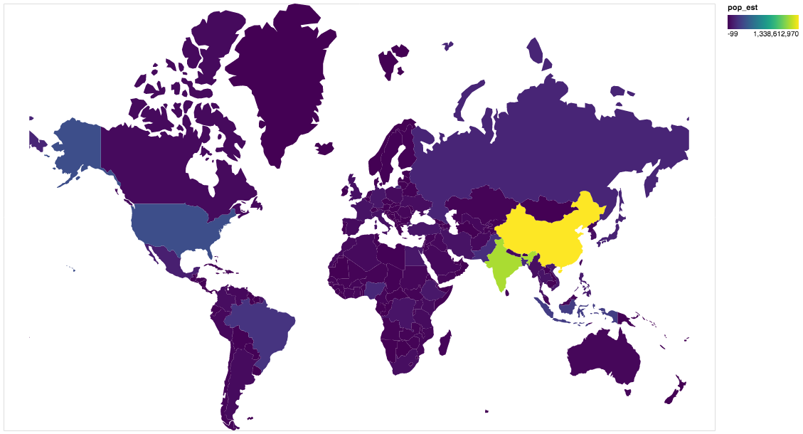
Example

import altair as alt
import geopandas as gpd
import gpdvega

alt.renderers.enable('notebook') # render for Jupyter Notebook

world = gpd.read_file(gpd.datasets.get_path('naturalearth_lowres'))

# GeoDataFrame could be passed as usual pd.DataFrame
alt.Chart(world[world.continent!='Antarctica']).mark_geoshape(
).project(
).encode(
    color='pop_est', # shorthand infer types as for regular pd.DataFrame
    tooltip='id:Q' # GeoDataFrame.index is accessible as id
).properties(
    width=500,
    height=300
)

output

Install

Dependencies

gpdvega requires:

  • Altair (>= 2.2.0 )
  • GeoPandas (>= 0.4.0)

User installation

using pip

pip install gpdvega

Changelog

See the changelog for a history of notable changes to gpdvega

Introduction to Geospatial Analysis in Python

Introduction to Geospatial Analysis in Python This repository is in support of a talk on geospatial data. Data To recreate all of the examples, the da

Dillon Gardner 6 Oct 19, 2022
Django model field that can hold a geoposition, and corresponding widget

django-geoposition A model field that can hold a geoposition (latitude/longitude), and corresponding admin/form widget. Prerequisites Starting with ve

Philipp Bosch 324 Oct 17, 2022
Fiona reads and writes geographic data files

Fiona Fiona reads and writes geographic data files and thereby helps Python programmers integrate geographic information systems with other computer s

987 Jan 04, 2023
A toolbox for processing earth observation data with Python.

eo-box eobox is a Python package with a small collection of tools for working with Remote Sensing / Earth Observation data. Package Overview So far, t

13 Jan 06, 2022
Geocode rows in a SQLite database table

Geocode rows in a SQLite database table

Chris Amico 225 Dec 08, 2022
Specification for storing geospatial vector data (point, line, polygon) in Parquet

GeoParquet About This repository defines how to store geospatial vector data (point, lines, polygons) in Apache Parquet, a popular columnar storage fo

Open Geospatial Consortium 449 Dec 27, 2022
A Python package for delineating nested surface depressions from digital elevation data.

Welcome to the lidar package lidar is Python package for delineating the nested hierarchy of surface depressions in digital elevation models (DEMs). I

Qiusheng Wu 166 Jan 03, 2023
Extract GoPro highlights and GPMF data.

Python script that parses the gpmd stream for GOPRO moov track (MP4) and extract the GPS info into a GPX (and kml) file.

Chris Auron 2 May 13, 2022
How to use COG's (Cloud optimized GeoTIFFs) with Rasterio

How to use COG's (Cloud optimized GeoTIFFs) with Rasterio According to Cogeo.org: A Cloud Opdtimized GeoTIFF (COG) is a regular GeoTIFF file, aimed at

Marvin Gabler 8 Jul 29, 2022
Spatial Interpolation Toolbox is a Python-based GUI that is able to interpolate spatial data in vector format.

Spatial Interpolation Toolbox This is the home to Spatial Interpolation Toolbox, a graphical user interface (GUI) for interpolating geographic vector

Michael Ward 2 Nov 01, 2021
ProjPicker (projection picker) is a Python module that allows the user to select all coordinate reference systems (CRSs)

ProjPicker ProjPicker (projection picker) is a Python module that allows the user to select all coordinate reference systems (CRSs) whose extent compl

Huidae Cho 4 Feb 06, 2022
A Django application that provides country choices for use with forms, flag icons static files, and a country field for models.

Django Countries A Django application that provides country choices for use with forms, flag icons static files, and a country field for models. Insta

Chris Beaven 1.2k Jan 03, 2023
This GUI app was created to show the detailed information about the weather in any city selected by user

WeatherApp Content Brief description Tools Features Hotkeys How it works Screenshots Ways to improve the project Installation Brief description This G

TheBugYouCantFix 5 Dec 30, 2022
Geographic add-ons for Django REST Framework. Maintained by the OpenWISP Project.

Geographic add-ons for Django REST Framework. Maintained by the OpenWISP Project.

OpenWISP 982 Jan 06, 2023
h3-js provides a JavaScript version of H3, a hexagon-based geospatial indexing system.

h3-js The h3-js library provides a pure-JavaScript version of the H3 Core Library, a hexagon-based geographic grid system. It can be used either in No

Uber Open Source 648 Jan 07, 2023
Computer Vision in Python

Mahotas Python Computer Vision Library Mahotas is a library of fast computer vision algorithms (all implemented in C++ for speed) operating over numpy

Luis Pedro Coelho 792 Dec 20, 2022
Tools for the extraction of OpenStreetMap street network data

OSMnet Tools for the extraction of OpenStreetMap (OSM) street network data. Intended to be used in tandem with Pandana and UrbanAccess libraries to ex

Urban Data Science Toolkit 47 Sep 21, 2022
A public data repository for datasets created from TransLink GTFS data.

TransLink Spatial Data What: TransLink is the statutory public transit authority for the Metro Vancouver region. This GitHub repository is a collectio

Henry Tang 3 Jan 14, 2022
Example of animated maps in matplotlib + geopandas using entire time series of congressional district maps from UCLA archive. rendered, interactive version below

Example of animated maps in matplotlib + geopandas using entire time series of congressional district maps from UCLA archive. rendered, interactive version below

Apoorva Lal 5 May 18, 2022
Stitch image tiles into larger composite TIFs

untiler Utility to take a directory of {z}/{x}/{y}.(jpg|png) tiles, and stitch into a scenetiff (tif w/ exact merc tile bounds). Future versions will

Mapbox 38 Dec 16, 2022